
a project bymojBrač

Places map

Places and stories of Brač

Explore the places, heritage and local producers of Brač. Suggest an addition and help build the island’s atlas.

Archaeology

Kopačina Cave

between Supetar and Donji HumacOther names: Kopačina, Pećina Kopačina, Špilja KopačinaLate Upper Paleolithic–Bronze AgeApproximate guide based on the outline of protected cultural property Z-4928; it does not indicate an entrance or passability. For the hillfort complex, the museum site is used rather than the full extent of the archaeological zone.

Summary

Kopačina is a cave archaeological site with evidence of human presence from the Late Paleolithic to the Bronze Age. Finds from the cave are important for the study of prehistoric life on Brač and the eastern Adriatic.

Protected cultural property Z-4928. The archaeological site is fenced; check current access conditions before arriving.
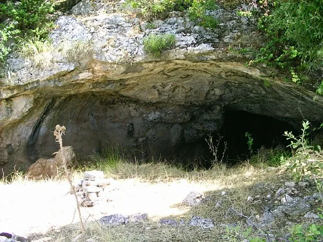
Entrance and rock formations of Kopačina Cave
Entrance and rock formations of Kopačina Cave · AK-PR Balkan · Wikimedia Commons · CC BY-SA 3.0 · licence

History and context

Research in the cave began in the late 19th century and was carried out systematically from 1978 to 1993, with more recent campaigns by the Archaeological Museum in Split. Finds span the Late Upper Paleolithic, Epigravettian, Mesolithic and Bronze Age. New AMS radiocarbon dates published in 2025 reassess the chronology and warn that layers from earlier excavations may have become mixed; some older classifications should therefore not be presented as definitive.

What the site reveals

The cave consists of a lit entrance area and an inner chamber. Excavations have yielded flint and bone artefacts, pottery, animal and human bones, and shells. The objects point to long-term use of the space, but the dating of individual groups of finds depends on their layer context and the methods of analysis.

Location and visiting

The cave is northwest of Donji Humac. A report by the Archaeological Museum in Split notes a protective fence because of earlier damage to the site. The marked point is approximate; check that access is permitted before setting out, do not enter the fenced research area, and do not remove archaeological material.


Visitor contributions

Do you know more about this entry?

A photo, an old postcard, a source link or local knowledge can help make the atlas more complete.

Schematic map of Brač with place markers

Every contribution is reviewed before publication.

Religious buildings
4 places

Separate map · local production

Find local producers

A map of family farms and other local producers on Brač. Browse by product type — olive oil, honey, cheese, cosmetics and more — and find basic information, contacts and official websites.

Open the producers’ map →
Local knowledge · Explore Brač

Help document Brač.

Do you know an old name, have a photo, know the location or have a source to share? Your contribution can enrich the island’s public atlas.

Suggest a connection between places →
Schematic illustration of a map with place markers
MOJ BRAČ · SECURE SIGN-IN

Sign in to Explore Brač

We send a one-time code to your email so you can save favourites. You do not need a password or separate registration. Your email and favourites list are stored in the Atlas database.