
a project bymojBrač

Places map

Places and stories of Brač

Explore the places, heritage and local producers of Brač. Suggest an addition and help build the island’s atlas.

Traditions · Nature

Trolokve on the Plateau near Gažul

Plateau between Vidova gora and GažulOther names: Trolokve, Brač, Trolokve kod Gažula, Trolokve na visoravni kod Gažulatraditional watering pondsApproximate location · based on a Google Maps marker

Summary

Trolokve on the Brač plateau is a group of three watering ponds along routes between Vidova gora and Gažul. They are connected with livestock farming and the use of water in the island's karst interior.
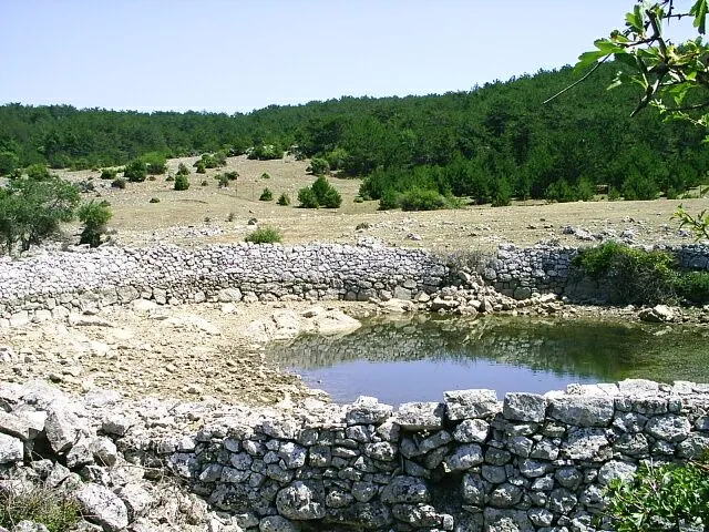
Trolokve on the Brač plateau is a group of three watering ponds along routes between Vidova gora and Gažul. They are connected with livestock farming and the use of water in the island's karst interior.

Stone-lined watering pond at Trolokve in the interior of Brač
Stone-lined watering pond at Trolokve in the interior of Brač · Martin Brož · CC BY 3.0 · resized and converted to WebP · licence

Water in the karst landscape

The ponds allowed herders to water their animals where there are no permanent surface streams. Their value is evident in their relationship to pastures, seasonal livestock movements and routes connecting settlements with the island's interior.

Three watering ponds at the crossroads

A local description links Trolokve with the meeting point of the Nerežišća, Bol, Dol and Pražnica areas. The route continuing north leads towards the Gažul shepherd settlement. Ponds with the same name lie closer to Supetar; these are two different sites.

Access and visiting

Trolokve is reached by plateau routes. Water levels change during the year, so the appearance of the site depends on rainfall and season. The ponds serve animals; do not enter the water, pollute the edges or disturb livestock coming to drink.

Visitor contributions

Do you know more about this entry?

A photo, an old postcard, a source link or local knowledge can help make the atlas more complete.

Schematic map of Brač with place markers

Every contribution is reviewed before publication.

Religious buildings
4 places

Separate map · local production

Find local producers

A map of family farms and other local producers on Brač. Browse by product type — olive oil, honey, cheese, cosmetics and more — and find basic information, contacts and official websites.

Open the producers’ map →
Local knowledge · Explore Brač

Help document Brač.

Do you know an old name, have a photo, know the location or have a source to share? Your contribution can enrich the island’s public atlas.

Suggest a connection between places →
Schematic illustration of a map with place markers
MOJ BRAČ · SECURE SIGN-IN

Sign in to Explore Brač

We send a one-time code to your email so you can save favourites. You do not need a password or separate registration. Your email and favourites list are stored in the Atlas database.